This past September Sean and I decided to take a day and go re-scout the Deer Park 4-Day trip. The trip begins near Silverton, Colorado. It has many of the classic Rocky Mountain features as it crosses high alpine terrain. The trail leads you to the large Silver Lake and the neighboring ghost town. Deer Park, though short in mileage, is quite the epic trip given all the amazing things seen in a short period of time. This 4-Day trip is perfect for Saddle and Spruce campers.
We felt this trip needed to be re-scouted for a few reasons:
- It’s an amazing trip suited to a variety of ability levels.
- There have been significant changes to the area resulting in some difficulty navigating.
- We had to figure out if this was a trip we could continue to send.

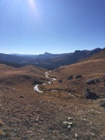
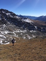
Sean and I headed towards Silverton one morning with the Deer Park itinerary in hand. We made small notes along the road for ways we could make the itinerary more clear for future trip leaders. We reconfirmed the appropriate drop point and then continued up the 4x4 road. The itinerary instructs trip leaders to leave the 4x4 road and climb to the pass. From the pass you can reach Silver Lake. We needed to find the exact point where trail met the 4x4 road. Trail scouting is a skill built with experience. Lost trails are often difficult to rediscover on your first try. Yet, if you use the map to find where the trail once was, or should be, you can follow a path back where you first looked for it. More often than not this results in discovery of the lost trail. This was the case for Sean and I that day. We had difficulty, as trip leaders before us had, finding the exact spot where the trail met the road. So we looked at the map, and noticed a few other spots where the trail once lay. We used land navigation to find such a spot, and did find a pretty healthy trail. We took note of that area for later. We continued to gain elevation on the rediscovered trail, following it all the way to the top of the pass. There we saw a wonderful view of Silver Lake and the neighboring ghost town.
What kind of changes can affect land navigation?
- The USGS map showed the trails in the area. Many of these trails have since become 4x4/ATV roads, and roads have been added to the terrain that are not on the map as well.
- Signage and postage can weather away, fall down, or dissappear completely (more on that later).
- Trails can grow faint or if enough time passes, overgrow completely.

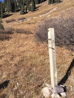
We enjoyed the view, had a few snacks and then decided to begin our descent. We made it back to the point where we discovered the lost trail and this time continued to follow it downhill. The trail remained pretty clear the whole way down until we could see the 4x4 road. It was about 1/10 of a mile before we met the road that the trail got very faint. From an uphill vantage point it was easy to see the faint trail descending to the 4x4 road. From the road it would be much more difficult to find the existing trail. We followed the trail back to the road. There we found a wood post marking the trailhead knocked over and discarded. This post was likely the old trail marker for the path that leads up and over the pass to Silver Lake. We propped the post back up, though we are rather certain it won’t last that way for long. It will likely get knocked down by snow this winter or a passing 4x4 vehicle during the summer. Trip leaders will still have to rely on their navigation skills for this trip. It will be easier for us to give instruction on how to find the trail. We hope our efforts re-scouting the Deer Park 4-Day will lead to successful trips in the future.
